RiverTools Helps Protect the Water Supply of Carbondale, Colorado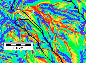
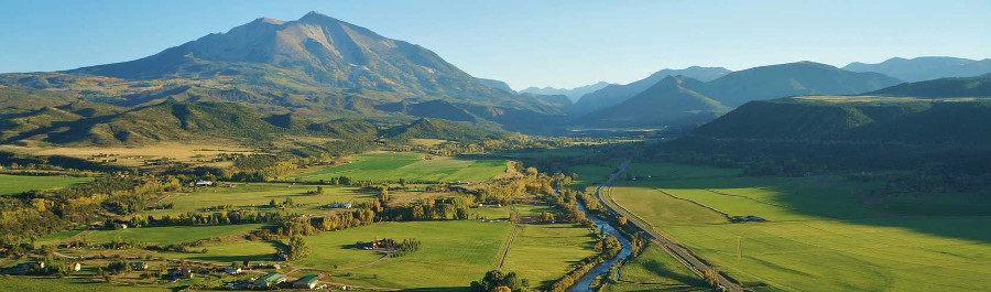
The Town of Carbondale, Colorado lies in the valley of the Roaring Fork River, about 10 miles north of Mount Sopris. More than 50 percent of the town's water supply is derived from Nettle Creek (north and south intakes), a pristine mountain stream network that flows down the western side of Mount Sopris to join the South Fork of the Roaring Fork River. The town's only other water source is a cluster of relatively shallow wells near the Roaring Fork River about a mile north of town. Carbondale's water system serves approximately 2,300 households with over 6,000 people. Hanging Valley Ranch (HVR) is a 55-acre property south of Carbondale — and the only privately owned property in the Nettle Creek watershed. (See white polygon in figure.) It is uniquely situated in the lower portion of the watershed just upstream of the confluence of its North Fork and South Fork. The remainder of the Nettle Creek watershed is owned by the US Forest Service (White River National Forest) and consists mostly of high alpine terrain with steeper slopes and elevations between 2300 meters (7546 feet) and 3929 meters (12,891 feet). In June of 2001, three construction-related incidents at Hanging Valley Ranch clogged the town's nearby water intake with mud, forcing it to shut down temporarily. As a result, Carbondale officials soon discovered that pesticides, herbicides and fertilizers were being applied on the ranch property in a manner that could potentially pollute the town's water supply. The Town of Carbondale then requested a temporary restraining order to stop construction on the land uphill from the town's main water intake and filed a lawsuit in Pitkin County District Court seeking $8,389 in damages from HVR. However, the owner of HVR filed a counter lawsuit against the town in U.S. District Court, arguing that the town violated federal equal protection laws and that he was being singled out for enforcement. That case was later dismissed, and the Colorado case was allowed to resume. Based on Colorado's "Watershed Protection Act" — Colorado Revised Statutes 31-15-707 (1)(b) — that allows cities and towns to control land use within five miles of their water source, Pitkin County District Court ruled in favor of the town in November 2003. HVR's owner went on to commission an Expert Report by Wright Water Engineers (WWE), which came out in June 2004, again arguing a minimal impact on the town's water supply, and filed an appeal with the Colorado Court of Appeals. In 2004, D. McKnight and S. Peckham, University of Colorado, Boulder, were asked by the town to review the findings of the WWE report. Their expert report of August 2004 did not support the WWE findings. In their report, RiverTools 3.0 was used for the topographic analysis, and in particular for computing detailed surface hydrologic flow paths for Mount Sopris and the HVR property. This analysis relied on USGS 7.5-minute quad DEMs with a horizontal resolution of 10 meters and the state-of-the-art mass flux method developed by Rivix Software, LLC. The surface hydrologic flow paths through the HVR property are such that approximately 70 percent of the property drains to the North Fork upstream of the North Intake, while the remainder drains to the South Fork downstream of the South Intake. The entire HVR property lies within 1.0 km (0.63 mi.) of the Nettle Creek water treatment facility and is therefore well within a 5-mile radius of the facility. In fact, the entire Nettle Creek watershed is within 4.7 km (2.9 mi.) of the facility. Although the Nettle Creek water source includes water from both the North and South Forks of Nettle Creek, the total contributing area (TCA) to the North Intake was computed using RiverTools to be 7.52 sq. km (2.94 sq. mi) while the total contributing area to the South Intake is only 1.16 sq. km (0.45 sq. mi). In September 2006, the appeals court ordered the case back to trial. Finally, in October 2007, the Colorado Supreme Court in Denver ruled 7-0 in favor of the town of Carbondale, ending the six-year-old court case. This ruling overturned the decision of the Colorado Court of Appeals and reinstated the 2003 Pitkin County District Court judgment in the town's favor. This final ruling sets an important precedent — it establishes the legal right of communities to regulate activities by individuals and corporations that could jeopardize their water supply. Other communities, such as Rifle, Colorado may be able to build on the ruling to protect their water supplies from oil and gas development. (See link to article below.) In March of 2015, the Town of Carbondale finalized its Source Water Protection Plan, designed to protect its water supply into the future and supported by the Supreme Court ruling. Many news articles have been written about this case. Here are a few of them, listed in chronological order:
The RiverTools 4.0 splash screen, shown below, is derived from a hillshaded image of a TCA grid for Mount Sopris. It shows the highly complex nature of surface hydrologic flow paths in the area, which display braiding and alternate between convergent and divergent flow. Despite the complexity, the Rivix "mass flux method" produces impressive results for this area while other algorithms perform poorly. Red corresponds to a large contributing area while blue and purple regions (e.g. ridges) have a small contributing area. Mount Sopris was also featured in the paper by Peckham (2001) that explains the mathematics of topographic saddles. The DEM data set for Mount Sopris is included with every RiverTools 4.0 installation as sample data, along with many other data sets. 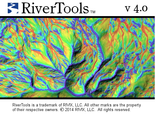
|
|
Copyright (c) 1998-2024, RIVIX, LLC. All rights reserved. Last update: June 5, 2024. Privacy statement. |