Key Benefits of RiverTools
Better Results in Less Time
Finding the best GIS (geographic information system) software for a given project can be difficult and time-consuming. Should you use the tools built into a general-purpose GIS package or should you use more specialized tools for some tasks and then import the results into other programs as needed? Is a general-purpose GIS program the best way to solve the problem at hand? People often choose to use software they already have and know how to use, even if they know or suspect that better solutions are available. This is partly due to the time required to learn new software and partly because they don't realize how much better their results could be if they invested in better tools. The purpose of this page is to explain some of the key benefits of our RiverTools product. Many of our customers are folks who really know their hydrographic GIS tools and use RiverTools to obtain better results in less time.
Cutting-Edge Solutions
When it comes to extracting hydrographic information from DEMs (digital
elevation models) there are several derived grid layers that are
fundamental.
 The most important ones are grids of
aspect (or flow direction),
total and specific contributing area (TCA/SCA),
slope, and several types of
curvature. This set of grids provides the foundation
for most of the other raster and vector products that you can
make with this type of software, such as river networks and basin
boundaries with attributes.
The simplest way to compute these derived grid layers is to use what
is known as the D8 method, first used in the 1980s.
Although the D8 method is still useful for certain tasks,
it is now known that it has significant limitations and
in particular can be grossly inaccurate in areas where flow lines are
divergent, as near drainage divides and on many hillslopes.
While much more accurate methods are now
available, the D8 method is still the only method that is provided in
most GIS packages for extracting hydrographic information from DEMs.
The much better D-Infinity method (Tarboton, 1997) has
been available in RiverTools since 2001, but still does not provide
a rigorous solution to the problem.
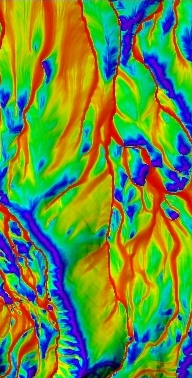
In 2003 we developed what we believe is the ultimate solution to
this important and challenging problem, which we call the
Mass Flux Method.
Our solution uses ideas from the
realm of computational fluid dynamics and agrees with analytic
solutions for several test surfaces. The figure at the right shows
complex flow paths in a TCA grid computed with the Mass Flux Method.
Places with a low contributing area (e.g. ridges) are blue, while
places with a high contributing area (e.g. channels) are red.
The two figures below show the
difference between D8 flow vectors and flow vectors from our Mass
Flux Method. Contour lines are purple, flow lines are yellow and
pixel boundaries are gray. Visual comparisons of contributing area
grids computed by these three methods can be seen in our
Image Gallery.
The most important ones are grids of
aspect (or flow direction),
total and specific contributing area (TCA/SCA),
slope, and several types of
curvature. This set of grids provides the foundation
for most of the other raster and vector products that you can
make with this type of software, such as river networks and basin
boundaries with attributes.
The simplest way to compute these derived grid layers is to use what
is known as the D8 method, first used in the 1980s.
Although the D8 method is still useful for certain tasks,
it is now known that it has significant limitations and
in particular can be grossly inaccurate in areas where flow lines are
divergent, as near drainage divides and on many hillslopes.
While much more accurate methods are now
available, the D8 method is still the only method that is provided in
most GIS packages for extracting hydrographic information from DEMs.
The much better D-Infinity method (Tarboton, 1997) has
been available in RiverTools since 2001, but still does not provide
a rigorous solution to the problem.
In 2003 we developed what we believe is the ultimate solution to
this important and challenging problem, which we call the
Mass Flux Method.
Our solution uses ideas from the
realm of computational fluid dynamics and agrees with analytic
solutions for several test surfaces. The figure at the right shows
complex flow paths in a TCA grid computed with the Mass Flux Method.
Places with a low contributing area (e.g. ridges) are blue, while
places with a high contributing area (e.g. channels) are red.
The two figures below show the
difference between D8 flow vectors and flow vectors from our Mass
Flux Method. Contour lines are purple, flow lines are yellow and
pixel boundaries are gray. Visual comparisons of contributing area
grids computed by these three methods can be seen in our
Image Gallery.
 |
 |
In addition to better methods for computing derived grid layers, RiverTools also offers multiple solutions to many other key problems such as
- how to route flow through flat areas
- how to determine where hillslopes end and channels begin, and
- how to compute slopes (see this tech tip).
More Accurate Measurements
The main purpose of hydrographic GIS software is to automate the measurement of many objects of interest, such as lengths, slopes and sinuosity of all channels in a river network, the areas and perimeters of watersheds and other polygons, or the flow distance to a water body. However, RiverTools may be the only GIS application that always takes the latitude-dependence of grid cell (or pixel) geometry into account when making measurements in DEMs that use Geographic coordinates.
Many of the DEM data sets that are currently in widespread use (e.g. NED, SRTM, ETOPO2, GTOPO30, MOLA) use a Geographic coordinate system which means that the edges of grids and grid cells are aligned with lines of latitude and longitude. Each grid cell in such a DEM spans a fixed angular measure such as 3 arcseconds, rather than a fixed length such as 30 meters. As a result, the distance spanned by the east-west dimension of each grid cell depends on its latitude. It is maximum at the equator and decreases to zero at the poles. Most GIS packages flatten this 3D data with a 2D map projection to create a new DEM in which every grid cell has the same fixed dimensions. They then go on to measure lengths, slopes and areas in this flattened grid, even though the original data has been distorted significantly by the map projection. In RiverTools, all lengths, slopes and areas are computed by integrating on the surface of the ellipsoid model that goes with the source DEM in order to avoid this geometric distortion; over 50 different ellipsoid models for Earth are built-in. This unique feature is especially important when working with DEMs at the regional, continental or global scale. With DEMs for smaller regions that use fixed-length grid cells (e.g. UTM or Albers Equal Area) RiverTools uses the standard approach. In addition, 36 different GCTP map projections are available for display purposes in Object Graphics mode and 19 in Direct Graphics mode.
Easy to Learn and Use
If you've tried working with GIS software and now feel that it is better left to GIS professionals, we understand how you feel. But we encourage you to try RiverTools and see how it is different. Our customers are frequently impressed by how easy it is to learn and use. A variety of built-in tools such as a Grid Calculator and the ability to use "matching wild cards" in input and output filenames also means that you don't need to write scripts or type commands at a command prompt in order to perform common tasks. (Although scripting with Interactive Data Language is still available as an option.) To see what some of our customers have said, click here.
Ease-of-use is why many instructors at universities have chosen RiverTools for use in their courses. We offer 10-user and 20-user educational lab licenses and have received very positive reviews from instructors. GIS software with advanced visualization can be a very effective teaching tool, but there is usually not enough time in a semester-long course for students to learn enough about a general-purpose GIS package to complete a nontrivial project. This shifts the instructor's focus away from the course material and often makes the course seem more like a tutorial for a specific GIS package. RiverTools has an intuitive graphical interface and a user-friendly, cross-linked HTML help system. (See these screen shots of the help system.) Rather than making you search a PDF file of the entire User's Guide for the answer to a question, RiverTools has a context-specific Help button in every dialog. The help system also includes illlustrated tutorials, a glossary (especially useful for students) and many "how-to" documents. It also has unique features such as executive summaries to help you learn about common DEM data sets and formats, a Recommended Reading section organized by topic and a section called Top 10 Things You Should Know About DEMs.
Ability to Handle Large Data Sets
The ability to handle very large data sets better than GIS packages with similar functionality has driven many of our sales, especially in more professional markets. For example, one large consulting company tried to use industry-standard GIS software to extract the information they required from a very large DEM (digital elevation model) and after running for 4 days it eventually crashed with no useful results. This kind of performance is a hidden cost that many companies face since they must pay their employees for the wasted time. The company then sought help from an outside consultant who suggested that they try RiverTools. With RiverTools, the same task took one day to run and they obtained the desired result. The company later hired us to develop additional custom tools for them.
Rivix, LLC has a great deal of experience in designing raster and vector computational modules that can efficiently extract hydrographic information from DEMs that are too large to process in main memory (RAM). This is done by balancing the workload between RAM and file I/O operations and is a design theme that has been applied consistently throughout RiverTools. Many packages with similar functionality use RAM-limited algorithms because they are easier to implement and require less time to develop. While it might seem that ever-increasing amounts of RAM would make this a non-issue, we've found that the data sets people want to work with are often bigger than the amount of RAM that they have available on their computer. And this has been the case for at least 15 years now. Similarly, reliance on virtual memory leads to poor performance since the operating system must then guess as to what information is required next. If you ever have trouble with a large data set in RiverTools we will work with you until the problem is resolved.
Everything in One Package
One of the frustrating trends in the GIS software market is to split essential functionality between several modules that are sold separately. For example, you may need to purchase a computational module as well as another module for visualization. Worse yet, you may then need to search the web for unsupported, third-party solutions in order to perform simple or common tasks. These tasks might include importing data in a widely-used DEM format (e.g. SDTS Raster Profile) or creating a plot of a longitudinal profile. Within its scope, RiverTools attempts to provide a complete solution in one package, and makes it easy to export extracted information for use in other GIS programs.
Reasonable Cost
It takes many years to develop and test professional-grade GIS software, and the number of pages of source code "under the hood" is often much more than all of the Harry Potter books put together. However, we have deliberately kept our prices low so that RiverTools remains within the reach of students, researchers and consultants with limited budgets. We believe that once you see everything that RiverTools can do, you will agree that the cost is nominal. And it is certainly more cost-effective to take advantage of our expertise and years of development and testing than to pay one of your employees to develop a limited, custom solution to one specific problem. If you need something that is not available in RiverTools, there is a good chance that we can work with you to add it to the next version.